Detroit topographic map
You can find on this page the Detroit topographic map to print and to download in PDF. The Detroit elevation map present the topography, river and relief of Detroit in Michigan - USA.
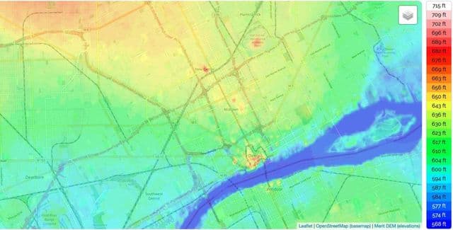
Detroit elevation map
The Detroit topographic map shows elevation, hills and landforms in Detroit. This elevation map of Detroit will allow you to know topography, river and relief of Detroit in Michigan - USA. The Detroit topographic map is downloadable in PDF, printable and free.
The location, topography, and nearby roads & trails around Detroit (City) can be seen in the map layers above. The latitude and longitude coordinates (GPS waypoint) of Detroit are 42.331427 (North), -83.0457538 (West) and the approximate elevation is 597 feet (182 meters) above sea level as you can see in Detroit elevation map. Detroit has four border crossings: the Ambassador Bridge and the Detroit–Windsor Tunnel provide motor vehicle thoroughfares, with the Michigan Central Railway Tunnel providing railroad access to and from Canada. The fourth border crossing is the Detroit–Windsor Truck Ferry, located near the Windsor Salt Mine and Zug Island. Near Zug Island, the southwest part of the city sits atop a 1,500-acre (610 ha) salt mine that is 1,100 feet (340 m) below the surface. The Detroit Salt Company mine has over 100 miles (160 km) of roads within.