

You can find on this page the Detroit buses map to print and to download in PDF. The Detroit bus system map and the Detroit trolley map present the network, stations and lines of the buses and trolley of Detroit in Michigan - USA.
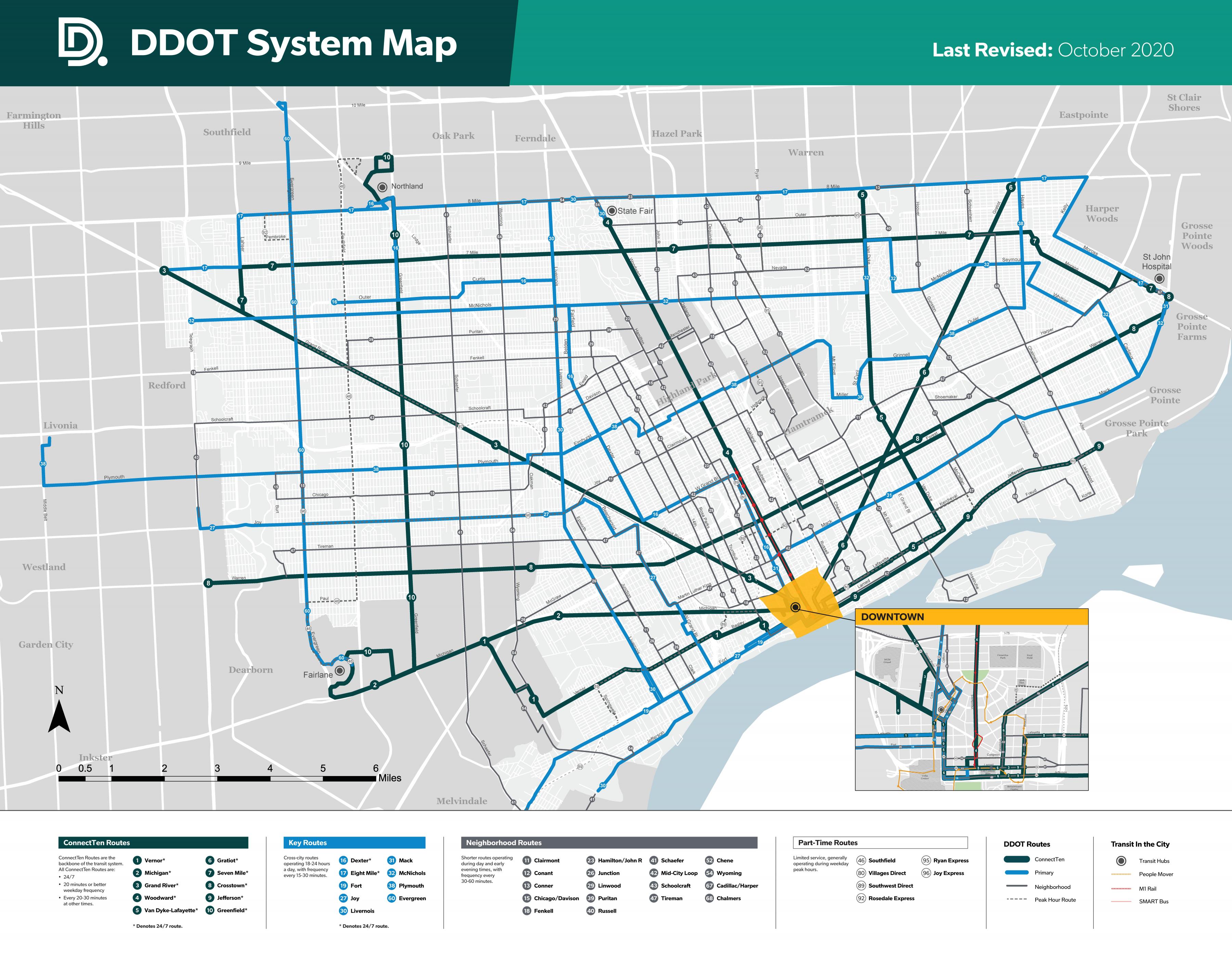
The Detroit bus map shows all the stations and lines of the Detroit bus system. This bus map of Detroit will allow you to easily plan your routes in the buses of Detroit in Michigan - USA. The Detroit bus system map is downloadable in PDF, printable and free.
The DDOT was created in 1922 as the Department of Street Railways. The department became the DDOT in 1974 under the Detroit City Charter (Detroit City Code Reference 7-1401) as its mentioned in Detroit bus map. Streetcar services was discontinued in 1956, with rail transit not resuming service until the Detroit People Mover was added in 1987. The People Mover is currently operated by a separate city agency called the Detroit Transportation Corporation. The Suburban Mobility Authority for Regional Transportation is the suburban bus system providing services outside the city, although SMART buses come in and out of the city on their routes. Greyhound Lines provides nation-wide service to the city of Detroit and the metropolitan area. Greyhound station is on Howard Street near Michigan Avenue. Detroit Amtrack Station is located at 11 West Baltimore Avenue and links to DDOT and SMART buses.
All of DDOT buses and routes are ADA accessible. Full and reduced fares are available for Dart regional and DDOT passes. The 4-hour pass is $2 and the 24-hour pass is $5 as its shown in Detroit bus map. DDOT sells bus passes at a number of convenient locations throughout the Detroit Metropolitan area for our customers. Bus stop signs in the DDOT service area are in the process of being changed. You will still see older signage in some areas as this transition is underway. DDOT buses are white with distinctive green and yellow stripes and the DDOT logo. The name and number of the bus route is displayed on the head sign located above the windshield of each bus. DDOT has 48 bus routes that serve the 138 square miles of Detroit and 23 surrounding communities.
The bus route number and name are displayed above the windshield. Wave to the bus to ensure the driver sees you. As you step onto the bus, you can ask the bus driver to confirm that they go to your destination. Pay the fare - $2 for 4 hours of unlimited rides on SMART, DDOT, and QLINE. The bus route number and name are displayed above the windshield. Wave to the bus to ensure the driver sees you. As you step onto the bus, you can ask the bus driver to confirm that they go to your destination. Pay the fare - $2 for 4 hours of unlimited rides on SMART, DDOT, and QLINE. There are four regional pass options available to riders. The Dart pass offers unlimited rides on DDOT and SMART buses, as well as the QLine streetcar: 4-hour Dart pass - $2, 24-hour Dart pass - $5, 7-day Dart pass - $22, 31-day Dart pass - $70 as you can see in Detroit bus map.